On April 26, 2018, the "Zhuhai One" remote sensing micro-nano satellite constellation 02 group satellites successfully launched into space. All five satellites have entered the predetermined orbit and are currently in good condition. The successful launch of 4 hyperspectral satellites means that Obit has become a domestic private company with hyperspectral remote sensing satellites, which has opened a new era of hyperspectral remote sensing!
1. What is hyperspectral remote sensing?
Hyperspectral remote sensing is actually a short name, and its full name is "hyperspectral resolution remote sensing". Hyperspectral remote sensing uses many narrow electromagnetic wave bands to generate spectrally continuous image data. It is not like distinguishing targets based on color differences in multi-spectral remote sensing, but analyzing what the target is based on the shape of the spectral curve of the spectral band. Spectral analysis is an important way for humans to understand the world with the help of light. If the visible light image provides planar information, then the hyperspectral remote sensing image provides spatial information. Through the analysis of the spectrum, the ability to collect image data is greatly improved.
2. What is the difference between multispectral and hyperspectral?
With the continuous improvement of spectral resolution, the development process of optical remote sensing can be divided into: Panchromatic → Color Photography → Multispectral → Hyspectral.
The panchromatic band (Panchromatic band), because it is a single band, is shown as a grayscale picture on the graph. Panchromatic remote sensing images generally have high spatial resolution, but they cannot display the colors of features. In actual operation, we often fuse it with the band image to obtain the image with both high resolution of the panchromatic image and color information of the multiband image. The panchromatic band generally refers to the use of a single band of about 0.5 microns to 0.75 microns, that is, the visible band from green to the back. The panchromatic remote sensing image is the image capture of the panchromatic wave band in the radiation of the ground object. Because it is a single wave band, the gray scale picture is displayed on the map. Panchromatic remote sensing images generally have high spatial resolution, but they cannot display the color of features.
Multi-spectral remote sensing: a remote sensing technology that breaks the electromagnetic radiation of ground objects into several narrow spectral bands and obtains information on different bands of the same target at the same time by photography or scanning.
Principle: Different features have different spectral characteristics, and the same features have the same spectral characteristics. Different ground objects have different radiant energies in different wave bands, and there are differences in the images obtained in different wave bands.
Advantages: Multi-spectral remote sensing can not only discriminate features based on differences in image shape and structure, but also discriminate features based on differences in spectral characteristics, which expands the amount of remote sensing information.
Multi-spectral photography for aerial photography and multi-spectral scanning for terrestrial satellites can obtain remote sensing data of different general segments. Images or data of sub-segment segments can be obtained by photographic color synthesis or computer image processing to obtain more abundant images than conventional methods. It also provides the possibility for computer recognition and classification of feature images.
Hyperspectral remote sensing originated from the multi-spectral remote sensing in the early 1970s. It combines imaging technology and spectral technology. While imaging the spatial characteristics of the target, each spatial image element undergoes dispersion to form tens or even hundreds. A narrow band is used for continuous spectral coverage, so the remote sensing data formed in this way can be described graphically using "image cubes". Compared with the traditional remote sensing technology, the image obtained by it contains rich spatial, radiation and spectral triple information.
Hyperspectral remote sensing technology has become a frontier technology in the field of remote sensing. Hyperspectral remote sensing has new characteristics different from traditional remote sensing:
1) Multiple bands: each pixel can provide dozens, hundreds, or even thousands of bands;
2) Narrow spectrum range: the band range is generally less than 10nm;
3) Continuous band: Some sensors can provide almost continuous features spectrum in the solar spectrum range of 350 ~ 2500nm;
4) Large amount of data: As the number of bands increases, the amount of data increases exponentially;
5) Increased information redundancy: As adjacent bands are highly correlated, redundant information also increases relatively.
advantage:
1) It is beneficial to use spectral characteristic analysis to study ground features;
2) It is beneficial to adopt various spectrum matching models;
3) Facilitate fine classification and identification of features;
The imaging spectrum is distinguished from the non-imaging spectrum according to the presence or absence of the image. The measurement results of the imaging spectrum are expressed in the form of an image. Each pixel is composed of a spectral curve, which can more accurately obtain the reflection spectrum of the target object. Compared with non-imaging spectrometers, the spectroscopic imagers are more accurate in positioning the samples.
As we all know, spectroscopic technology can detect the physical structure, chemical composition and other indicators of the measured object. Multi-spectral instrument and hyper-spectral instrument are based on point measurement, and the hyper-spectral imager measurement is the spectrogram on the target surface. Therefore, hyperspectral imaging technology is an inevitable result of the development of spectral analysis technology and image analysis technology, and is the product of the perfect combination of the two. Hyperspectral imaging technology not only has spectral resolution capability, but also image resolution capability. Using hyperspectral imaging technology can not only perform qualitative and quantitative analysis on the object to be detected, but also perform localization analysis on it.
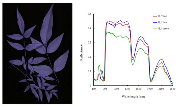
Figure 1 Spectral reflectance of different parts of the blade (1000-2500nm)
The main working part of the hyperspectral imaging system is the imaging spectrometer, which is a new type of sensor. The purpose of developing such instruments is to obtain a large amount of narrow-band continuous spectral image data, so that each pixel has almost continuous spectral data. It is a series of optical images of light waves at different wavelengths, usually contains tens to hundreds of bands, and the spectral resolution is generally less than 10nm (GaiaSky-mini2 of Sichuan Shuangli Spectrum Technology Co., Ltd., which can have up to 1440 bands , Spectral resolution up to 2.8nm, spectral sampling interval up to 0.41nm). Since the hyperspectral image obtained by hyperspectral imaging can provide an almost continuous spectral curve for each pixel in the image, it can obtain more abundant spectral data information than multispectral while obtaining spatial information on the object to be measured These data information can be used to generate complex models to discriminate, classify, and identify materials in images.
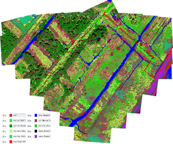
Figure 2 UAV hyperspectral images are used to identify different features classification
Obtaining the hyperspectral image of the test object through hyperspectral imaging contains the rich spatial, spectral and radiation triple information of the test object. This information not only shows the image characteristics of the spatial distribution of ground features, but also may obtain the radiation intensity and spectral characteristics of a certain pixel or group of pixels. Image, radiation and spectrum are three important features in hyperspectral images. The organic combination of these three features is hyperspectral images.
The hyperspectral image data is a data cube. Generally, the horizontal and vertical coordinates of image pixels are represented by z and Y, respectively, and the wavelength information of the spectrum is represented by (Z is the axis). The data cube consists of continuous two-dimensional images along the spectral axis at intervals of a certain spectral resolution.
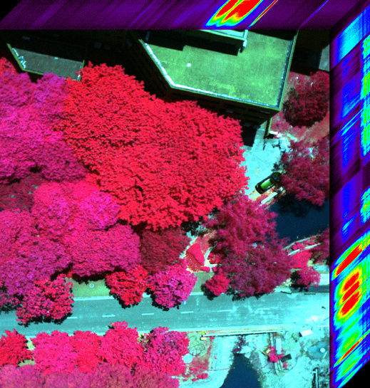
Figure 3 Three-dimensional hyperspectral view
The imaging spectrometers used on the ground are mostly push-broom, equipped with a rotary or linear stage to produce two effects: the imaging spectrometer moves while the object to be measured is stationary, or the imaging spectrometer is stationary while the target is moving. At present, there are already new types of ground imaging spectrometers, such as the GaiaField and GaiaSky-mini series of visible-near infrared imaging spectrometers produced by Sichuan Shuangli Spectrum Technology Co., Ltd., using the internal scanning device of the instrument to achieve push-broom imaging, namely the spectrometer and The hyperspectral imaging can be completed without movement of the measured object, without the need to be equipped with a displacement gimbal, and the instrument is more lightweight and portable, which is convenient for field use.

Figure 4 Built-in push-broom portable hyperspectral imager GaiaField
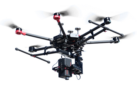
Figure 5 Built-in push-broom UAV hyperspectral imager GaiaSky-mini
LED is favored by manufacturers because of its energy saving, small size, long life and safe DC voltage power supply. The ultra-thin LED copy table adopts the backlight technology of liquid crystal display. Produced, the light evenness is very good, enough to be comparable to the display. In addition, the panel material adopts reinforced safety optical glass with excellent hardness and light transmittance, which is scratch-resistant, aging-resistant, long-lived, and good evenness. It has also been popular with animation workers.
A3 LED Light Pad,LED Light Pad Diamond Painting,LED Light Up Drawing Pad
Guangdong Jishengke Industrial Co.,Ltd , https://www.jskpads.com